
Blog 8: Beyond the Last 800 Years: The Mystery of the Waipoua Stone Settlement
- Kerry Paul

- May 5
- 5 min read
Updated: Jun 30
JOURNEY 1 - SERIES 4 - BLOG 8 - A PART OF 10 BLOGS IN SERIES 4. - Reading time: 6 Mins

This blog continues our examination of archaeological features in New Zealand that may preserve evidence older than the last ~800 years. Our second case study is the Waipoua Stone Settlement: a large, partially investigated complex of stone-built features now largely hidden beneath regenerating forest. This discussion adds another dimension to New Zealand’s origin story. These migration patterns contribute to broader debates surrounding Southeast Asian migration to New Zealand and are frequently compared with established interpretations of Polynesian migration to New Zealand. Together, these competing perspectives continue to shape ongoing discussions about New Zealand’s first settlers.
Waipoua Stone Settlement
Location and setting
Waipoua Forest lies on State Highway 12 on Northland’s west coast, roughly 45 km north of Dargaville, between Dargaville and Ōmāpere. The forest is best known today for its kauri ecosystem, but it also contains an extensive cluster of stone-built archaeological features.

The wider forest covers about 130 km² and includes an Archaeological Reserve of approximately 645 hectares. Archaeological work in the area took place largely between 1973 and 1984. Importantly, only parts of the overall complex were systematically investigated, and large areas remain unexplored or undocumented in detail.
Investigations and what was recorded
The most significant field programme was led by archaeologists from the University of Auckland from 1983. Work was carried out across approximately 200 hectares and involved recording hundreds of individual locations. The team documented more than 2,000 stone features, including walls and enclosures, with many already partly obscured by regenerating native forest and pine. Access limits imposed by landowners meant parts of the broader landscape could not be investigated in depth. Published reports list many recorded features and artefacts, but (as is common in preliminary survey work) do not make definitive claims about who built the structures or when they were constructed.

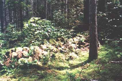

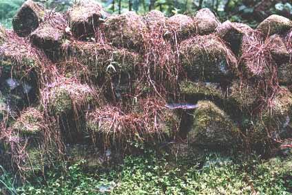

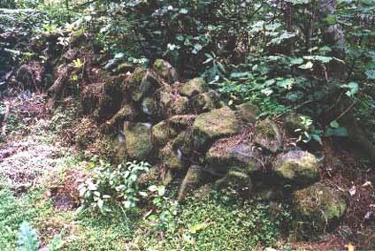

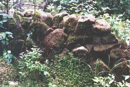
Selection of Stone Structures in the Waipoua Forest
Environmental time-depth (kauri as a rough guide)
Waipoua is home to two of New Zealand’s largest and oldest known kauri: Tāne Mahuta (often estimated at roughly 2,000–2,500 years old) and Te Matua Ngāhere (often estimated at roughly 2,500–3,000 years old). These ages suggest long ecological continuity in parts of the forest, but they do not, on their own, date the stone features. They do, however, underline a key challenge: if the area has been forested for long periods, structures built on open ground could have been progressively covered, altered, or recontextualised as vegetation regenerated and soils accumulated.
Visibility today and the case for LiDAR
Much of the complex is now difficult to see on the ground because dense regeneration obscures low stonework. Photographs and field notes from the 1980s indicate that some walls and related features were visible at that time, but present-day canopy and understory cover make the overall layout hard to reconstruct from surface inspection alone.
A modern way to re-map the landscape without large-scale ground disturbance would be LiDAR (Light Detection and Ranging). LiDAR uses laser pulses to build high-resolution 3D models of the ground surface. In forested terrain it can sometimes “see through” vegetation by filtering returns from leaves and branches, revealing subtle earthworks and stone alignments. A LiDAR survey could help identify the extent of walls, enclosures, terraces, and trackways, and guide any future, minimal-impact verification on the ground.
What the stone features include
Related stone features have also been reported beyond Waipoua Forest (north and south of the main reserve), though many are more degraded. Across the wider area, the recorded stonework includes combinations of:
stacked stone walls and alignments
enclosures/compounds and possible terraces
collapsed circular or beehive-like stone structures
hearths and stone-lined working areas
large platform-like or “altar” structures (interpretation uncertain)
incised standing stones or obelisk-like markers (interpretation uncertain)
stone-lined drains or waterways
standing stone circles
overland marker systems (mounds, cairns, and sighting pits)
Scale, significance, and open questions
Whatever their precise purpose, the number of recorded features and their distribution across a large area suggest sustained planning and labour investment over time. Large stone complexes are typically not the work of a single short occupation; they often accumulate through maintenance, expansion, and reuse across generations. However, the presence of extensive stonework does not automatically translate into a specific population size: some features may be episodic, ceremonial, or seasonal rather than residential. What the site most clearly indicates is that the landscape was being organised in a structured way for repeated use.
Key questions for future research
Extent: How far do the stone features extend beyond the areas surveyed in the 1970s–1980s?
Function: Which features relate to gardening, water management, pathways, or other practical activities, and which (if any) reflect ceremonial use?
Chronology: Can secure dates be obtained from sealed deposits associated with walls, terraces, or hearths?
Sequence: Was the complex built in one main phase, or does it represent multiple building episodes across long periods?
Regional context: How do Waipoua’s features compare with stonework recorded elsewhere in Northland and across New Zealand?
Why the story may remain incomplete (and what can still be done)
Because Waipoua is a high-value ecological and cultural landscape, large-scale excavation is unlikely. Dense regeneration, kauri protection requirements, and access constraints all limit what can be done on the ground. Even so, a great deal could be learned through low-impact approaches: LiDAR mapping, targeted field verification, soil and vegetation history studies, and carefully designed test excavations in a small number of locations where impacts can be minimised. If secure dating and clear functional interpretations could be established, Waipoua would become a pivotal case study for understanding how complex land use developed in Northland—and what that might imply for the longer human history of New Zealand.
Interpreting function from surface stonework alone is difficult. Depending on their form and location, some features could have served as boundary markers, retaining walls, garden or terrace edges, pathways, water-management structures, ceremonial focal points, or foundations for timber buildings. Confirming any of these interpretations would require detailed mapping, excavation of selected test areas, and secure dating of associated deposits.
Interpreting age and landscape change
One working hypothesis is that at least some stone features were constructed when parts of the landscape were more open than they are today. In many environments, stone alignments associated with gardening, boundaries, or trackways become progressively obscured as scrub and then forest regenerate—especially in warm, wet climates. That said, the relationship between stonework and forest cover is not straightforward: forests can advance and retreat over centuries, and some structures can be built within forested settings. Establishing a reliable sequence therefore depends on direct archaeological dating (for example, dating charcoal or other material sealed beneath or against walls, or using soil and vegetation histories in adjacent profiles).
Key Takeaways
Large, unexplained stone complexes exist: The Waipoua Forest contains thousands of stone features, indicating sustained, organised activity over time, but their origin, purpose, and age remain unresolved.
Evidence may be hidden, not absent: Dense forest, geological activity, and sediment buildup likely obscure much of the archaeological record, meaning the lack of clear early evidence does not rule out earlier human presence.
Modern methods could reshape understanding: Techniques like LiDAR and targeted excavation offer the potential to uncover the full extent, function, and timeline of these structures, which could significantly alter interpretations of New Zealand’s early human history.
To continue reading Series 4 we invite you to join us:



Comments