
Blog 1: Beyond the Maps: The Evidence for Early Portuguese Exploration of New Zealand
- Kerry Paul

- May 27
- 5 min read
Updated: Jun 30
JOURNEY 2 - SERIES 2 - BLOG 1 - A PART OF 3 BLOGS IN SERIES 2 - Reading time: 4 Mins 30 Secs

Evidence of early Portuguese exploration extends beyond cartography.
This includes:
Artefacts Found in Wellington Harbour
Māori Oral Traditions
British Admiralty Charts
New Zealand and British Historians
Artefacts Found in Wellington Harbour
A sixteenth-century European iron helmet
A large iron cannonball linked to the Spanish Armada era
Both were recovered from Wellington Harbour and are considered possible evidence of early European contact.
Mendonca’s chart of Wellington Harbour is meticulously detailed, highlighting key features that could only be captured through firsthand experience. The harbour would have been an ideal location for the Portuguese to make repairs and replenish their fresh water supply after enduring a storm off Australia’s eastern coast. This discussion adds another dimension to New Zealand's origin story: Were the Portuguese in New Zealand first? These findings continue to shape debates surrounding New Zealand's First Settlers. The evidence also contributes to broader discussions about New Zealand Early European Explorers.
Over the years, evidence has surfaced supporting Mendonca’s presence in Wellington Harbour. Around 1900, the Wellington Museum acquired an iron helmet found in the harbour, which was confirmed to be of sixteenth-century European origin. This helmet bears a resemblance to those housed in the Lisbon Military Museum. In 1926, a Wellington Harbour Authority dredge unearthed a large iron cannonball, typical of the Spanish Armada of 1588, which was subsequently donated to the Wellington Museum. Portuguese ships fought under Spanish command in 1588.


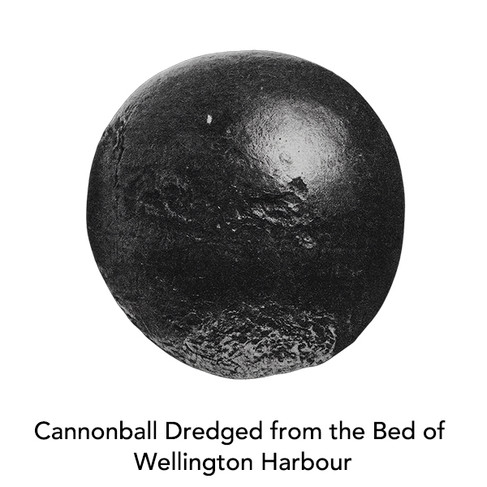
The origins of these items have been the subject of much speculation. One theory suggests the presence of a sixteenth-century Portuguese vessel in Wellington Harbour.
Māori Oral Traditions
Historical Māori accounts describe large square-rigged ships crewed by armoured sailors carrying swords and lances. These descriptions appear more consistent with sixteenth-century Portuguese vessels than later Dutch or English explorers.
In the early 1900s, New Zealand historian WJ Elvy interviewed an elderly Māori who recounted a tradition from a Wellington iwi describing the arrival of a large square-rigged vessel. The crew, armed with swords and lances, wore shiny coats of armour that caused the Māori’s stone weapons to fall off. The multi-racial crew included fair-skinned and darker individuals, likely Portuguese officers accompanied by Indian, Malay, or Indonesian crew members. The references to swords and plate armour indicate a sixteenth-century vessel, predating the times of Tasman or Cook.

British Admiralty Charts
One piece of evidence exists with the British Admiralty Chart No. 748 printed in 1803 containing references to a Portuguese discovery of New Zealand around 1550. This Chart was used for the next 50 years. Cook Strait was named as the “Gulf of the Portuguese” and East Cape is “Cabo Fermoso” which is Cape Beautiful in Portuguese. Written on the map next to New Zealand was:
“New Zeeland (Discovered and named by Tasman 1642 but where eastern coast was known to the Portuguese, about the year 1550)”
This information was repeated in the British chart published in 1817.
The reason why the British Admiralty cited Mendonca’s voyage “around 1550” was because the Vallard Atlas was not produced until 1547 and did not come into possession of the British Library until 1790. The Atlas was gifted by Joseph Banks who sailed on Captain James Cook’s first expedition decades earlier. Did Banks have the Vallard Atlas on board during Cook’s first expedition? Cook in his private correspondence after he returned to England commented on places he visited in Australia being different from what he had been told.

New Zealand, British and Portuguese Historians
Many sources supported the Portuguese discovering New Zealand and/or Australia: Major 1859, Hocken and McNab (1894), Collingridge (1895), McIntrye (1977, 1982), Wallis (1981), Trickett (2007), and also the British Admiralty between 1803-56.
The Curator of Maps at the British Library, Helen Wallis in 1981 commentary on the Dieppe maps (including the Vallard Atlas) stated:
“…it is notable how many of these names are descriptive of physical features…others seem to record the events and personal associations of an exploring voyage, including saints’ names…it is clear that the land represents a discovery made on a European voyage or coastal exploration. Secondly, it was apparently not a region of settled and civilized populations whose peoples’ would tell a visiting expedition the names of towns and other places (in fact there was no sign of towns). Thirdly, the number of Portuguese names suggests that the voyage was made, or at least recorded, by the Portuguese.”
Jose Alberto Leitao Barata (2003) discovered references to Mendonca’s expedition in the 1962 work of Padre Antonio da Silva Rego, who sourced Portuguese records in Mozambique (unaffected by Lisbon earthquake/fires) where the Portuguese had bases in the sixteenth century.

In New Zealand, two of the leading historians of the nineteenth century Drs Thomas Hocken and Robert McNab commented on the authenticity of the Dieppe Maps. Their pre-eminence continues today is significant library collections.
Dr Thomas Hocken, early New Zealand historian whose name is perpetuated in the Hocken Library, Dunedin and Dr Robert McNab, early New Zealand historian who donated his collection to the Dunedin Public Library, today the McNab New Zealand Collection contains around 83,000 items.

In 1894 they wrote:
“ Doubtless before Tasman, there were voyagers who had visited New Zealand…We are justified in thinking that there are buried in the old archives of Portugal and of Spain journals which, if found, would give an earlier account of New Zealand than those which we consider our earliest…The iron-bound chests of Portugal and of Spain are the probable repositories of these treasures, or they may have been emptied into the Papal and monkish libraries…and may lie covered with the accumulated dust of centuries”

Dr Hocken further commented on the Vallard Atlas:
“This strange map shadows forth the strong probability that New Zealand was known to Europeans, and most likely to the Portuguese, at least 350 years ago” ie mid-1550’s.
Peter Trickett, Beyond Capricorn (2007) conducted a detailed process of identification of Australian coastal features and North Island, New Zealand which is critical to proving the accuracy of the Vallard Map. By translating the Portuguese place names, he demonstrated they accurately describe the physical feature on the modern map.
Portuguese navigators often named geographical features based on their physical characteristics, which helped in identifying and navigating these areas. For example, they might name a mountain "Serra" (meaning "mountain range") or a river "Rio" (meaning "river"). This practical approach was useful for navigation and mapping.
To continue reading Series 2 we invite you to join us:


Comments