22. What can we learn from the archaeological excavation at Waipoua Stone Settlement, in the Waipoua Kauri Forest?
- Kerry Paul

- Jun 7, 2025
- 3 min read
Updated: Apr 13

Waipoua Forest is located on State Highway 12, 45 km north of Dargaville, on Northland's west coast, between Dargaville and Omapere.
Today, the Waipoua Forest (130 sq km) contains an Archaeological Reserve spanning approximately 645 hectares. Numerous archaeological sites were excavated between 1973 and 1984. Importantly, large areas remain unexplored.
The most significant excavation was conducted by archaeologists from the University of Auckland, beginning in 1983, who worked on 600 sites spread across 200 hectares. The team discovered over 2,000 stone structures, many of which were already covered by regenerating native forest and pine trees. However, the landowners restricted the team from fully investigating the entire site. Their subsequent reports provide extensive lists of the artefacts found but make no claims about who built the structures or their age.
The Waipoua Kauri Forest is home to New Zealand's two oldest and largest trees: Tane Mahuta, estimated to be 2,000-2,500 years old, and Te Matua Ngahere, believed to be 2,500-3,000 years old. These trees offer a guide to the age of the Waipoua Forest.
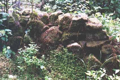
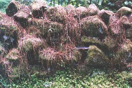
Today, the stone structures are buried beneath the forest. Some structures were visible in the 1980s:
Selection of Stone Structures in the Waipoua Forest:


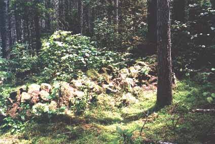


The true extent of the stone structures is now obscured by dense native forest cover. To gain any indication of their layout, the use of LiDAR (Light Detection and Ranging) would be required. LiDAR creates detailed 3D maps by reflecting light off surfaces, allowing for the outline of surface features to be discerned, even in areas with dense vegetation.
Similar stone structures exist outside the Waipoua Forest area, both to the north and south, though these are in a more degraded state. In total, the structures consist of stacked stone walls, compounds, collapsed stone beehive houses, hearths, large altar structures, incised obelisks, stone-lined waterways, standing stone circles, and overland marker systems (comprising mounds, cairns, and sighting pits).
These structures could have served a variety of purposes, including as boundary markers, retainer walls, ceremonial shrines or altars, or foundations for wooden structures. Were these constructed by New Zealand's first settlers?
It’s logical to assume that the stone structures were built before the forest became established, as they would have been constructed across a wide area of land that was not yet forested. In other words, the stones were likely used for their intended purpose, such as marking garden plots, and eventually fell into disuse before the regenerative forest took over.

The construction of the stone structures would have taken decades, if not longer, requiring large numbers of workers. Those who initiated the work would have passed the task on to subsequent generations, resulting in a gradual expansion of the complex. It’s likely that different groups of people contributed to its construction over time, and the site would have been highly attractive to future generations because of the efforts of those who built it.
Most importantly, the scale and geographical spread of the stone structures strongly suggest that thousands of people may have lived in the area.
Due to the rapid forest regeneration typical of a sub-tropical environment and the value of the kauri tree ecosystem, it is unlikely that a major excavation will ever be carried out to reveal the full history of who, how, and why these stone structures were originally built. Such research could be pivotal in uncovering New Zealand’s early history.
What archaeological features in New Zealand can you nominate where the identity of the builders remains uncertain or debated?
THE EVIDENCE about New Zealand's first settlers continues in the following Blogs
Your next read in the series: 23. What can we learn from the archaeological excavation at Poukawa Moa Excavation, near Hastings?


The article presents a fascinating glimpse into the Waipoua Forest and its archaeological features. The uncertainty surrounding the builders of the stone structures highlights a crucial aspect of historical inquiry. The lack of conclusive evidence regarding who constructed these features raises questions about our understanding of the past. It’s intriguing how the structures are intertwined with the region's ecology, especially concerning the significance of the Bizzo https://bizzo.geek.nz/ trees in this context. The potential use of LiDAR to explore these features is an exciting prospect, suggesting that much remains undiscovered.
The discussion surrounding the stone structures in Waipoua Forest raises intriguing questions about New Zealand’s early inhabitants. The potential identification of these features as a Kiwi Treasure https://kiwitreasure.org.nz/ is compelling, yet without thorough investigation, the true purpose and identity of their builders remain elusive. The combination of archaeological limitations and dense forest cover complicates our understanding, leaving much to speculation.
The article presents a thought-provoking exploration of the Waipoua Forest's archaeological significance. The mention of the possible builders of the stone structures raises important questions about our understanding of early New Zealand history. The implications suggest that we might be the Lucky Ones https://luckyones.geek.nz/ in the sense that we have the chance to unveil mysteries of past civilizations, though obstacles like forest coverage complicate full investigations.