4. Mendonca sailed around the bottom of the North Island by following the coastline south of Cape Egmont?
- Kerry Paul

- Sep 14, 2025
- 3 min read

Mendonca’s voyage around the North Island continues as we further explore the Portuguese discovery of New Zealand and New Zealand’s early European explorers.
Mendonca decided to sail south of Mt Egmont (Taranaki). The Vallard Map shows the coastline running east and eventually turning back toward the southwest before ending abruptly at a prominent round headland. This headland matches the shape of Cape Terawhiti, at the extreme southwestern point of the North Island.

*Source: Trickett, P. (2007): Beyond Capricorn, East Street Publications.
Behind this headland, Mendonca’s chart depicts a large, deeply indented bay running in a northerly direction, the harbour of New Zealand’s capital city, Wellington. Early Māori sightings report a single vessel with great white sails off the coast of New Zealand. The question arises whether Mendonca’s ship was alone, and what happened to the other three vessels. Were the other ships destroyed at Warrambool or Gabo Island in Australia or somewhere else on the southwestern coast of the North Island?
After leaving Port Nicholson harbour (Wellington Harbour), the map evidence indicates the Portuguese carrack sailed southeast until it reached another prominent headland where the land turned abruptly north. This would be Cape Palliser at the southeastern extremity of the North Island.
Heading north along the Wairarapa coast, there are several errors of detail, perhaps because the ship was out to sea to avoid dangerous currents close to shore, and Mendonca had no telescope. Some coastal peaks were mistaken for islands.
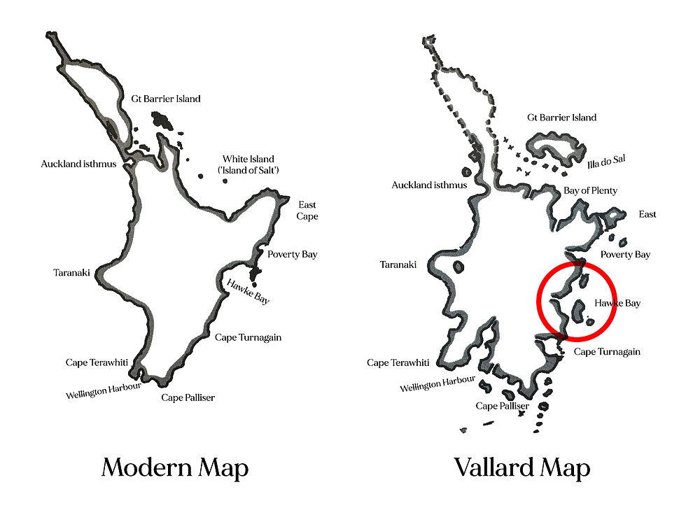
The pronounced curve of Hawkes Bay is easily identifiable, along with Capes Turnagain and Kidnappers. At the northern end of the Vallard Map’s Hawke Bay is the prominent Mahia Peninsula, which, while narrowly connected to the mainland, is drawn as an island. A smaller island off its southern tip is Portland Island.
Source: Trickett, P. (2007): Beyond Capricorn, East Street Publications.
The final deeply indented bay shown on this coast is Poverty Bay. Accurately depicted is Young Nicks Head. Next, Mendonca’s chart depicts a very large headland jutting out towards the northeast. This represents East Cape, with a mountain range at the cape’s northern extremity mistaken for an island. Beyond this cape towards the northwest is a large semicircular bay corresponding in stylized form to the Bay of Plenty.

Source: Trickett, P. (2007): Beyond Capricorn, East Street Publications.
There is an island on the Vallard Map off the Bay of Plenty coast named Illa do Sal. In Portuguese, “Sal” means salt. Later, James Cook named this White Island for the same reason Mendonca named it Sal. The volcano produces large amounts of gypsum, a white mineral salt resembling common salt. The island’s shimmering white slopes led Mendonca to associate it with salt, a highly prized preservative commodity during this period.

Source: Trickett, P. (2007): Beyond Capricorn, East Street Publications.
The following blogs continue to describe Mendonca’s voyage based on the Vallard map of Illa do Magna
Your next read in the series: 5. How did Mendonca spend his time in Auckland and surrounding islands?


Comments